Scan, Measure, Report, Sketch
The complete 360° documentation platform for mitigation specialists responding to water, fire, and storm damage emergencies with speed and precision.
No credit card required. Start measuring in minutes.
Trusted by professionals working with leading brands and insurers
Everything mitigation teams need
Capture and document water, fire, and storm damage with comprehensive 360° imagery for accurate assessments and faster response.
360° Photo Capture
Upload 360 photos from any device or camera. Compatible with all major 360 camera brands.
Remote Measuring
Measure rooms, walls, and spaces remotely without returning to the property. Save time and travel costs.
Team Collaboration
Collaborate on projects, phases, and documentation with your entire team in real-time.
Professional Reports
Generate detailed reports with measurements, annotations, and 360° views for clients and stakeholders.
Easy Sharing
Share interactive 360° tours with clients, adjusters, and contractors with a simple link.
Cloud Storage
All your projects safely stored in the cloud. Access from anywhere, on any device.
Simple as 1-2-3
Get started in minutes with our intuitive workflow designed for emergency response teams handling urgent mitigation projects.
Scan
Capture 360° photos of any space using your smartphone or 360 camera. Upload directly to the cloud.
Measure
Use our powerful tools to measure walls, rooms, and spaces directly in the 360° view. No site visits needed.
Share & Collaborate
Generate reports, share with clients, and collaborate with your team. Everyone stays on the same page.
Convert scans into .ESX files for Xactimate
Seamlessly export your measurements and floor plans to .ESX files that are perfect for Xactimate, or .FML files as needed. Streamline your entire workflow from scan to estimate.
.ESX Export
Direct export to Xactimate-compatible files
.FML Support
Export to FML format when required
CSV & PDF Reports
Export measurement data in multiple formats
project_measurements.esx
Ready for Xactimate
floor_plan.fml
FML Format
measurements_report.csv
Spreadsheet Export
360° Tours, Sketches, and Estimates
Streamline your inspection and restoration workflow with our comprehensive solution that brings all your documentation needs together.

Comprehensive 360° Documentation
Capture every detail of damaged properties with high-resolution 360° photography that provides complete visual documentation for insurance claims.
- Capture unlimited 360° photos per property with any compatible camera
- Add detailed notes and damage markers directly to your 360° tours
- Generate comprehensive reports with visual evidence for adjusters
Xactimate and CoreLogic Sketch Outputs
Convert your 360° documentation into accurate digital floor plans with precise measurements for restoration planning and insurance claims.
- Receive industry-standard sketch files compatible with major estimating software
- Expert-created sketches with detailed room dimensions and features
- Include plumbing fixtures, cabinetry, and architectural details for complete documentation
Estimating as a Service
Streamline your estimating process with tools that connect your documentation directly to your preferred estimating software.
- Fast turnaround times with priority processing for urgent claims
- Reliable, consistent estimates from experienced professionals
- Quality assurance review process ensures accuracy every time

One app for your entire scanning and .ESX process
Stop juggling multiple tools. 3D Measure handles everything from capture to export, all in one seamless workflow designed for insurance and restoration professionals.
Explore Your Projects in Full 3D and Measure Collaboratively
Experience exactly what your clients and team members see. Navigate through spaces, take measurements, and explore every detail.
Click and drag to look around. Use the navigation controls to move between rooms.
Real-Time Collaboration
Connect your mitigation crews with adjusters, property managers, and emergency coordinators for rapid response and approval.

Work Together From Anywhere
3D Measure enables real-time collaboration between emergency response teams, insurance adjusters, and property owners.
Virtual Walkthroughs
Guide adjusters through the property remotely with live video calls integrated directly into the 3D model.
Real-Time Annotations
Multiple team members can add notes, measurements, and damage markers simultaneously.
Instant Sharing
Share interactive 3D models with clients and adjusters with a single click for immediate feedback.
Built for Mitigation Specialists
Whether you're responding to floods, fires, or storm damage, 3D Measure helps you document and communicate damage instantly.
Insurance
Document claims with 360° evidence, measure remotely, and speed up the adjustment process.
Restoration
Create comprehensive before and after documentation for restoration projects.
Construction
Document construction progress and coordinate with teams using immersive 360° views.
Inspections
Scale your inspection process with efficient 360° capture and remote measurement tools.

Quick Capture
Five seconds per room
Document Every Project with Ease
With 3D Measure, capturing comprehensive project documentation has never been easier. Simply walk through the space with your 360° camera, and let our software handle the rest. No complicated setup, no steep learning curve—just point, scan, and done.
Save Hours on Every Job
Replace tedious manual measurements with fast 360° scans that capture everything in minutes.
Never Miss a Detail
360° documentation ensures you capture every angle, reducing costly return visits.
Custom Dashboards Built for Your Team
Branded order management designed for mobile, so your field crews can scan, upload, and order from any property. Receive your sketch floor plan and Xactimate file in 24 hours or less.
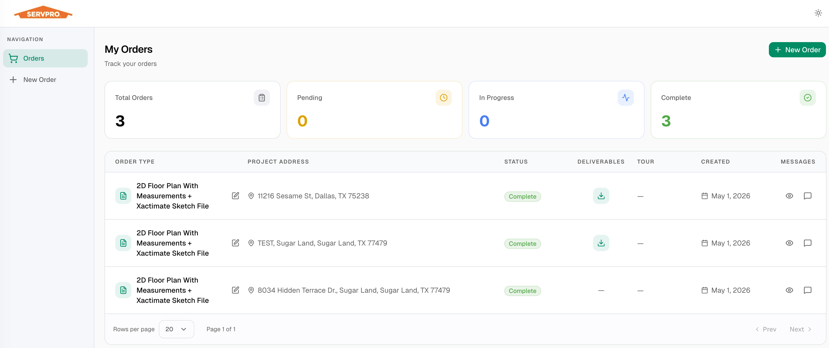
Scan 360
Capture the property with your 360 camera in minutes.
Upload
Upload directly from the field on any mobile device.
Click Order
Submit your sketch order with a single tap.
Receive Files
Get your floor plan and Xactimate file in 24 hours or less.
Ready to Transform Your Mitigation Response?
Join thousands of mitigation specialists who trust 3D Measure for rapid, accurate emergency documentation.
No credit card required. Start measuring in minutes.